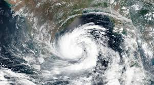
As super cyclone ‘Amphan’ barrels towards the Indian shores in West Bengal and Odisha, lakhs of people have been evacuated from vulnerable areas and shifted to safety. Amphan—the second super cyclone to have had formed over the Bay of Bengal in two decades—is expected to make a landfall between Digha, some 180 km south of Kolkata in West Bengal, and Hatiya islands in Bangladesh during the afternoon to evening hours of Wednesday, May 20, with the maximum sustained wind speed of 155-165 kmph gusting to 185 kmph.
As cyclone Amphan, which is pronounced as Um-pun, rumbles towards the Indian coastline, we have tried to answer some of your most frequently asked questions.
So, what is the present status of cyclonic storm ‘Amphan’?
As per the latest update issued by the India Meteorological Department (IMD), it has weakened into ‘extremely severe’ cyclonic storm and lay centred over northwest and adjoining westcentral Bay of Bengal, about 250 km south of Paradip in Odisha and 390 km south-southwest of Digha in West Bengal and 540 km south-southwest of Khepupara in Bangladesh.
How devastating was the first super cyclone in Bay of Bengal in 1999?
In 1999, Odisha was ravaged by a super cyclone that left around 10,000 people dead along its trail of destruction. One of the powerful cyclones of the 20th century, the 1999 super cyclone had also damaged nearly 20 lakh hours, killed about two lakh livestock and affected about 2.5 to 3 million people, leaving large tracts of agricultural land unfit for cultivation for a long time due to salinity.
What are the weather forecasts for Odisha and West Bengal?
As per the IMD, heavy to very heavy rainfall at isolated places are expected over north coastal Odisha (Balasore, Bhadrak, Mayurbhanj, Jajpur, Kendrapara and Keonjhargarh districts) on May 20. Coastal districts of Gangetic West Bengal (East Medinipur, South and North 24 Parganas) are likely to experience light to moderate rainfall at many places commencing from May 19th evening. Rainfall intensity is likely to increase gradually and become maximum on May 20.
Villagers on the Bay of Bengal coast walk as they are evacuated by volunteers as a precaution against Cyclone Amphan at Bakkhali, South 24 Parganas, West Bengal, India, Tuesday, May 19, 2020. (AP Photo)
Rainfall at most places with heavy to very heavy falls at a few places and extremely heavy falls at isolated places likely over Gangetic West Bengal (east and west Medinipur, south and north 24 Parganas, Howrah, Hoogli, Kolkata and adjoining districts) on May 20 and isolated heavy rain over interior districts on May 21.
Which other states are likely to witness a change in its weather pattern?
The IMD has forecast that Sikkim will witness light to moderate rainfall at most places with heavy to very heavy falls over most of the districts of Sikkim on May 21. Light to moderate rainfall is also expected at most places with heavy to very heavy falls at a few places over western districts of Assam and Meghalaya on May 21.
Fishermen should avoid these sea routes on these days
A total suspension of fishing operations has been advised till May 20. Fishermen have been advised not to venture into North Bay of Bengal and adjoining central Bay of Bengal during May 19 to 20. Additionally, fishermen are advised against venturing into north Bay of Bengal along and off north Odisha, West Bengal and adjoining Bangladesh coasts till May 20.
Puri: Fishermen pull their boat back to shore amidst rough sea, ahead of the landfall of Cyclone Amphan, at Puri beach, Tuesday, May 19, 2020. (PTI Photo)
A storm surge of about 4-5 metres above astronomical tide is likely to inundate low lying areas of south and north 24 Parganas and about 3-4 meters over the low lying areas of East Medinipur district of West Bengal during the time of landfall.
What all damage is expected in Odisha and Bengal?
In Bengal districts such as East Medinipur, South and North 24 Parganas, Howrah, Hoogli, Kolkata, extensive damage is expected to all types of kutcha houses and some damage to old badly managed pucca structure. Also, there is a potential threat from flying objects. Extensive uprooting of communication and power poles is also likely along with disruption of rail/road at several places. Aside from these, extensive damage to standing crops, plantations, orchards and blowing down of palm and coconut trees, uprooting of large bushy trees are expected.
Boats are anchored at a fishing harbor at Paradeep, on the Bay of Bengal coast in Orissa, India, Tuesday, May 19, 2020. (AP Photo)
In Odisha districts of Jagatsinghpur, Kendrapara, Bhadrak, Balasore, Jajpur and Mayurbhanj, total destruction of thatched houses and extensive damage to kutcha house are expected. While major damage to kutcha and pucca roads are likely, minor disruption of railways, overhead power lines and signalling systems are expected. Additionally, widespread damage to standing crops, plantations, orchards, falling of green coconuts and tearing of palm fronds and blowing down of bushy trees like mango are expected.
What is the likely post-landfall outlook?
Post landfall, the system is very likely to continue to move north-northeastwards, across Gangetic West Bengal and Bangladesh and weaken gradually. It is very likely to maintain the intensity of cyclonic storm till the morning of May 21 and thereafter will weaken into a deep depression over Bangladesh.


