Weather Alert: Coldwave conditions are likely in isolated pockets of Himachal Pradesh, Jammu & Kashmir, and Ladakh on various days.
The India Meteorological Department (IMD) predicts light to moderate rainfall and thunderstorms, accompanied by hailstorms, in Northwest and Central India on December 27 and 28 due to a Western Disturbance interacting with easterly winds. Scattered rainfall and snowfall are expected in the Western Himalayan region, with isolated rainfall in the adjoining plains throughout the week.
Read More: Former PM Manmohan Singh Admitted To AIIMS Delhi After Health Deteriorates
Coldwave conditions are likely in isolated pockets of Himachal Pradesh, Jammu & Kashmir, and Ladakh on various days. Dense fog is expected in Himachal Pradesh, Punjab, Haryana, Chandigarh, Assam, Meghalaya, Odisha, and Rajasthan during late nights and early mornings throughout the week.
The easterly wave will bring isolated rainfall to parts of South Peninsular India. Rainfall is forecasted to be normal to above normal in northwest India, near normal in the southern peninsula, and below normal elsewhere.
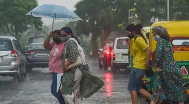
Delhi-NCR wakes up to light rain
Delhiites started their day with light rainfall on the morning of December 27, as reported by the India Meteorological Department (IMD). The minimum temperature for the day was recorded at 12 degrees Celsius. Additionally, parts of Noida and Ghaziabad also received light showers in the morning bringing the temperature down. A video shared by news agency ANI captured scenes from India Gate, showcasing the rainy weather in the National Capital.
Read More: Delhi air pollution: AQI ‘very poor’, IMD predicts respite with rain and falling temperatures
Orange alert issued for Himachal Pradesh
The Meteorological Department has issued an orange alert for Himachal Pradesh, signaling the possibility of severe cold and snowfall in certain areas. Meanwhile, Jammu & Kashmir and Punjab are under a red alert, with warnings of intensified coldwave conditions.
Western disturbance to bring rain and snow
A western disturbance is expected to impact northwest and central India on December 27 and 28, bringing moderate rainfall, thundershowers, and hailstorms. Himachal Pradesh is likely to experience a significant drop in temperatures, with heavy cold conditions predicted on December 28.
Read More: ‘Punjab Bandh’ Announced By Protesting Farmers On December 30; Here’s What’s Open, Closed
Northern India battles severe coldwave
Northern India continues to reel under a harsh coldwave. In the Kashmir Valley, temperatures plunged well below freezing, causing water bodies like Dal Lake to freeze. Srinagar recorded a low of -7 degrees Celsius on Wednesday night, slightly up from -7.3 degrees Celsius the previous night. Other areas, including Gulmarg (-6 degrees Celsius), Pahalgam (-8.6 degrees Celsius), Qazigund (-7 degrees Celsius), and Kokernag (-9 degrees Celsius), reported similarly frigid conditions.
In Himachal Pradesh, higher altitudes are expected to witness snowfall starting December 27. Shimla is forecasted to experience temperatures of 14.8 degrees Celsius with snowfall, while Kufri is likely to record 9.8 degrees Celsius.
Dense fog and rain in Rajasthan
Rajasthan is grappling with dense fog and intermittent rainfall. Fatehpur recorded the state’s lowest temperature at 3.8 degrees Celsius, followed by Churu at 5 degrees Celsius and Pilani at 5.7 degrees Celsius. Cities such as Jaipur, Ajmer, and Udaipur are expected to receive light to moderate rainfall due to the approaching western disturbance.
Coldwave grips Punjab and Haryana
Punjab and Haryana continue to endure biting cold wave conditions. Chandigarh reported a minimum temperature of 7.3 degrees Celsius on Thursday, with officials predicting the chill to persist in the coming days.