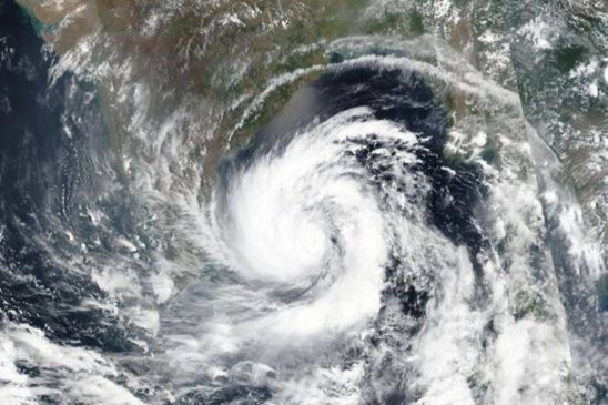
Cyclone Remal Alert: The Indian Meteorological Department (IMD) said that a low-pressure area is expected to form over the southwest Bay of Bengal around May 22 and will most likely move northeastwards, forming into a depression over the central parts of the Bay of Bengal by May 24. According to officials tracking the depression, there are chances that it will intensify into a cyclone. If it does transform into a cyclone, it will be the first cyclone of this pre-monsoon season.
“The depression is expected to intensify into a cyclone with chances of further intensification. These alerts will be issued soon. If the cyclone moved towards the Indian coast, then it will support monsoon and if it moves towards Myanmar then it will be a spoiler and can negatively impact monsoon onset,” an IMD official said.
Read More: India needs to create 115 mn jobs by 2030
According to Roxy Mathew Koll, climate scientist at Indian Institute of Tropical Meteorology, a low pressure system is likely to develop in the south Bay of Bengal during 22 23 May.
“A low-pressure system is going to develop in the south Bay of Bengal during 22 23 May. Will it evolve as #CycloneRemal moving to the east coast? Ocean and atmospheric conditions are favourable in south Bay, with 2 3 C warmer sea surface temperatures and a Madden Julian Oscillation (MJO) reaching there,” Roxy Mathew Koll, climate scientist at Indian Institute of Tropical Meteorology wrote on X on Sunday.
“Sea surface temperatures (SSTs) in the south Bay of Bengal have been 2 3 C warmer than usual for quite some time. Persistently high sea surface temperatures provide constant supply of heat and moisture, essential for cyclone formation. The Madden Julian Oscillation (MJO), an eastward traveling band of clouds coupled with the winds and warm ocean waters, is moving to the south of Bay (the red line indicates this). These winds provide a rotational trigger for the cyclones to initiate” he said.
Read More: Vande Bharat Express Train Operating From Delhi; Check List, Routes, Timings, Schedule
Cyclone Remal Update: IMD Forecast
The weather department has forecast that monsoon in the country is expected to make onset over Kerala around May 31.
Cyclone Remal Update: Rainfall Warning
The IMD’s forecast warns that we should brace ourselves for significant rainfall, hitting heavily in certain areas around North Odisha and Gangetic West Bengal around May 24th and 25th.
Anticipate strong wind currents, beginning from May 23, likely reaching 40-50 kmph and even surging up to 60 kmph across the central Bay of Bengal region. These winds are expected to sweep through the neighboring areas of North Bay of Bengal from the following day onwards, the wind intensity escalating to 50-60 kmph, and peaking up to 70 kmph.
So, it looks like we’re in for some choppy to severe sea conditions over the central Bay of Bengal starting May 23rd, and this wild weather is set to roll out over the North Bay of Bengal from the 24th.
Read More: Schengen Visa Fee Hike in June To Make Your Trip To Europe Costlier, Check Details Here
Cyclone Update: Advisory Issued For Fishermen
Fishermen are kindly advised not to venture into the central part of the Bay of Bengal beginning on May 23, extending to the northern parts from May 24. Any fishing crews presently out at sea should make their way back to the mainland before May 23. In addition to this, the scorching heat wave will likely persist across the plains of Northwest India for the foreseeable future. Meanwhile, regions in northern Madhya Pradesh and Gujarat can expect the heat to continue in full swing over the next five days.


